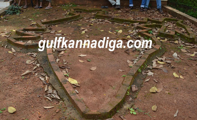
Karkala; Dec 06: In general, if you ask anybody that where the Kanyakumari is, answer quite obvious is that Kanyakumari is in South. But if you ask students of Karkala taluk’s Muniyalu higher primary school, they will say, Kanyakumari is in north. How can it be possible? Has the world map been changed? Yes, because the world map drawn on the floor with bricks in front of the head master’s cabin was upside down. (When you look at this world map standing at south, you may feel, it is correct)
In the world map picture, if you hold it in any angle, the directions can be told to students. But in Muniyalu higher primary school, where directions of the map supposed to be drawn correctly, has changed the direction of the future students by school administrators. They could have drawn showing correct directions like in south, Kanyakumari, north Kashmir, west Arabian Sea and in the east Bay of Bengal. But in the map drawn on the floor with bricks, in front of head master’s office showing like in south Kashmir, north Kanyakumari, east Arabian Sea and in west Bay of Bengal.
Based on this map, when question was asked with one of the students of the school, which direction is Mumbai? He pointed his fingers in between east and south. But if you stand in front of this map, in reality it was shown, Mumbai was shown in between east and north.
Here in Muniyalu higher primary school, instead of drawing India’s map geographically showing correct directions, was drawn wrongly and conveying wrong messages to the students. The authorities from academic department should take an appropriate action against this institution, where teachers are misguiding the future of the students.