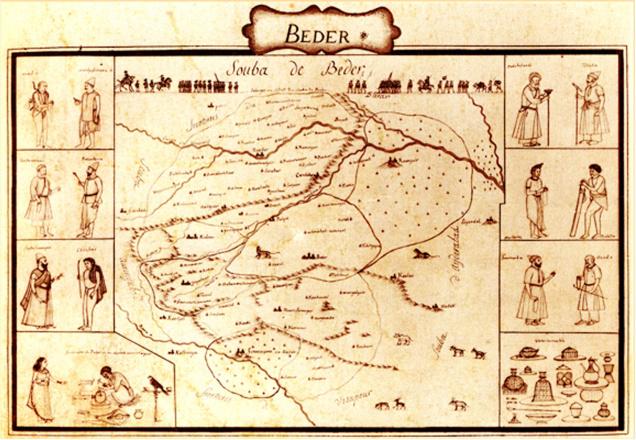
The map is included in an atlas produced by Colonel Jean Baptiste Gentil, Military Adviser to the Nawab of Awadh Shuja-ud-Daula
In exciting news for historians, an ancient atlas, which includes a map of Bidar, prepared by French officer Colonel Jean Baptiste Gentil, Military Adviser to the Nawab of Awadh Shuja-ud-Daula (1763 to 75), was found tucked away in the India Office Library at London. The map shows Bidar, which was once a capital city of the Bahamani Kingdom and an educational centre with historical importance.
Historian and painter Rehman Patel, who reproduced the map, said that in the interests of preserving the historic post and throwing more light about the history of the Bidar and its cultural heritage, the State government should put pressure on the Union government to bring it back to India and place it in Bidar.
Illustrations
He added that Col. Gentil had utilised the services of local artists to produce a series of illustrations on the political and social history of India.
Dr. Patel pointed out that illustrations were included on either side of the map. They reveal the representatives of different Sufi orders and thick forests with drawings of wild animals. These drawings also include Bidri craftsman and the different wares that were produced in Bidar. The bespectacled artisan at the bottom left of the page is portrayed as engraving a floral pattern on the side of a globular huqqa, with his wife and pet parrot looking on.
The illustration is reinforced by having a caption: ‘Fabrique de Beder ou on incruste en or et argent’ (Beder workshop for inlaying in gold and silver).
At the bottom right corner, there is a drawing of the types of wares produced: ‘vases incrustes’, or ‘inlaid vessels’. These include a globular huqqua on a stand, a bell-shaped huqqua, spittoons, boxes, a ewer and wash basin.
Reference to Bidriware
Dr. Patel said so far, the earliest unambiguous reference to Bidriware was in the Chahar Gulshan, written in Persian in 1759 AD. This includes a statistical account taken, on internal evidence, from an earlier compilation of about 1720 AD.
Book II of the Chahar Gulshan is ‘an account of five Subhas (administrative divisions) of Deccan’, one of the five being Bidar, referred to by its Bahmani and Mughal names. A manuscript in the British Library has the following passage: ‘The subah of Mohammadabad called Zafarabad (Bidar).
Bidar was also known from an illustration in an atlas produced in Faizabad, Uttar Pradesh in (1770 AD) under the Nawab of Awadh (Oudh) Shuja-ud-Daula, who ruled from 1754-75 AD. During this period, Bidar was under the control of Muhammad Ghauth Saif-ud-Daula, but he died shortly after his appointment, and his brother Saif Jang Najm-ud-Daula Bahadur became the governor in his place.
Dr. Patel said that enquiries at the office of the Deputy Commissioner in Bidar revealed that the district administration did not have a copy of the manuscript and the atlas produced by Col. Gentil.
(The Hindu)


